Waterway information

Kind:
Inland
Driving areas:
🇳🇱 Netherlands
Length:
15.5 km¹
¹River kilometers or bank length recorded in NavShip, including river arms and harbor entrances.
Availability:
Completely recorded
Recent Update: 04.03.2025²
² This date indicates when an adjustment last took place in the course of the body of water
Recorded:
Locks: 0
Harbours / marinas: 9
Bridges: 5
Berths: 0
Slipways: 0
Fuelstations: 0
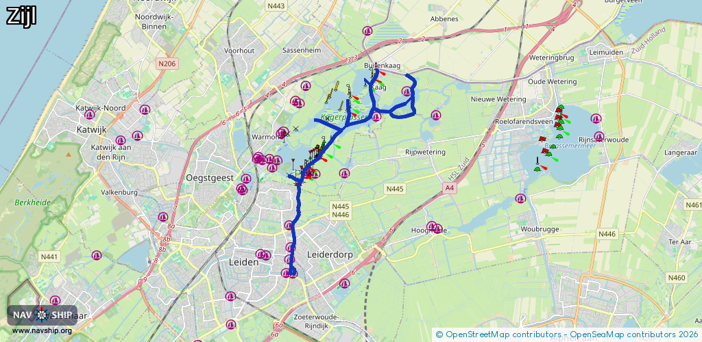
Route:
Please wait, loading route graphic...
Request waterway overview map with symbol legend here (Link).
Information about data associated with this body of water (14 available):
Data by OpenSeaMap (c) OSM contributors, www.openseamap.org
| # | Kind | Coordinates | Name | Information |
|---|---|---|---|---|
| 1 | Marina | 52.16385,4.51434 | 2021-11-11T14:53:05Z | |
| 2 | Marina | 52.17088,4.51383 | 2025-07-16T18:59:54Z | Watersportvereniging Leiden https://wvleiden.nl/ |
| 3 | Marina | 52.18641,4.52226 | 2023-08-06T22:22:18Z | |
| 4 | Marina | 52.18722,4.52349 | 2025-09-23T08:04:08Z | |
| 5 | Marina | 52.18652,4.52636 | 2022-05-08T16:27:54Z | Botenstalling Zijldijk |
| 6 | Marina | 52.21181,4.57256 | 2020-10-07T19:12:51Z | passantenhaven Keverhaven |
| 7 | Marina | 52.20412,4.55716 | 2022-09-18T17:02:33Z | Spijkerboor https://www.campingspijkerboor.nl/ |
| 8 | Marina | 52.15582,4.5155 | 2025-08-13T17:28:48Z | Jachthaven Waardeiland |
| 9 | Marina | 52.16018,4.514 | 2024-09-21T17:08:13Z | Wsv De Kooihaven |
| 10 | Bridge | 52.16122,4.51473 | 10.4 | Clearance height: 2022-06-06T15:00:17Z m Maximum passage width: 2.5 m Movable bridge (e.g. lifting bridge or drawbridge) opening |
| 11 | Bridge | 52.1695,4.5155 | 10.5 | Clearance height: 2022-06-06T14:56:14Z m Maximum passage width: 4.9 m Movable bridge (e.g. lifting bridge or drawbridge) fixed |
| 12 | Bridge | 52.16947,4.51532 | 10.2 | Clearance height: 2022-06-06T15:35:59Z m Maximum passage width: 4.5 m Movable bridge (e.g. lifting bridge or drawbridge) opening |
| 13 | Bridge | 52.15775,4.51519 | Unknown | Clearance height: 2020-10-29T10:58:07Z m Movable bridge (e.g. lifting bridge or drawbridge) fixed |
| 14 | Bridge | 52.18496,4.51671 | 5.4 | Clearance height: 2018-04-15T00:50:02Z m Maximum passage width: 1.4 m fixed |